
Twitter Feed
SourceConnecte! Marketplace With A Mission
Earlier this year, GC GlobalNet launched a new breed of B2B e-commerce sites. Curated by Kevin L. Jackson, SourceConnecte (with an “eâ€) went live with three strategic goals in mind: Efficiently leverage modern…

Potential vs. Reality: Is Edge Computing Real?
Edge computing provides compute, storage, and networking resources close to devices generating traffic. Its benefits are based on an ability to provide new services capable of meeting stringent operational requirements…

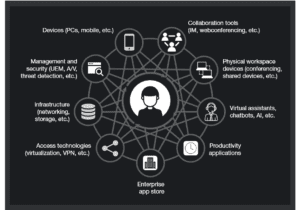
Enabling Digital Transformation
Digital transformation integrates technology into all areas of an organization’s business or mission. Its fundamental purpose is to create and deliver innovative and industry-changing products and services to a global…

The ThinkShield Story Part 1: The Challenge
The cybersecurity challenge seems to be growing daily. Threats are becoming more sophisticated, and attacks are becoming more destructive while the corporate world’s response seems to resemble a deer…

CIO dream team: Who’s in and why?
Today’s CIO navigates the twin challenges of enabling new business models and managing rapid technological change. Cloud computing strategies are now table stakes. CIOs must make complex decisions about using…

Digital Transformation and the Mainframe
Digital transformation infuses digital technology into all areas of an organization’s business or mission. Its fundamental purpose is to create and deliver innovative and industry-changing digital products and services to…

Composable Architecture Q&A. Are you ready?
Q: Is it time for my company to jump on the composable architecture bandwagon? A: Composable architectures are quickly becoming essential to the modern enterprise. Citing a recent Forrester study:…
Increase Productivity by Reducing Technology Distraction: Lessons from Forrester Research
Workplace productivity is hurt every day by the very technology developed and purchased to improve it. Forrester announced this surprising conclusion in their latest “How To Wake Up From The Nightmare…

Unveiling the end-to-end capabilities for the networked society
An Interview with Henrik Basilier By Kevin L. Jackson The telecom industry is rapidly moving towards a future in which networks must have the capabilities of delivering services with the…

AT&T Finance Solutions GM on Shrimping, Software, and CX
Helping clients address the trends and challenges presented by the Financial Services industry is the main focus for René Dufrene in his role as General Manager of Finance Solutions at…
In their February blog post, “BI’s Next Frontier: Geospatial Cloud Computing“, Margot Rudell and Krishna Kumar succinctly described this need:
“Competitive superiority and prosperity require timely interpretation of space and time variables for contextual, condition-based decision making and timely action. Geospatial cockpits with cloud computing capabilities can now integrate the wealth of cloud data like macroeconomic indicators on the web with internal operations information to help define and execute optimal business decisions in real-time.”
In fact, if Washington, DC CTO Bryan Sival has his way, Washington would become the first “Geocity in the Cloud“:
“‘The city is already a heavy supplier of mapping applications, having 26 apps that mash maps up with data on crimes, evacuation routes, school data, emergency facilities, addresses of notaries public, leaf collection, and much more.’
Sivak also wants to provide ways for citizens to update city maps or augment maps with additional information such as the location of park benches and traffic lights. The idea is to take crowdsourcing to a higher level of detail by offering the capability to use this geospatial data to mark not just locations but documents and data relevant to the place.”
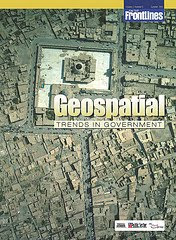
If you’re interested in a detailed look at this growing trend, you should definitely take a look at the most recent On The Frontline publication titled “Geospatial Trends In Government“. In the electronic magazine, Robert Burkhardt, Army Geospatial Information Officer, highlights the four major geospatial trends that are driving the use of Geospatial technologies in government. You can also read about the Army’s Buckey System, which provides high-resolution urban terrain imagery for tactical missions in Iraq and Afghanistan.
No wonder the NGA and Google are moving fast to link up with each other 🙂
![]()

( Thank you. If you enjoyed this article, get free updates by email or RSS – KLJ )
Cloud Computing
- CPUcoin Expands CPU/GPU Power Sharing with Cudo Ventures Enterprise Network Partnership
- CPUcoin Expands CPU/GPU Power Sharing with Cudo Ventures Enterprise Network Partnership
- Route1 Announces Q2 2019 Financial Results
- CPUcoin Expands CPU/GPU Power Sharing with Cudo Ventures Enterprise Network Partnership
- ChannelAdvisor to Present at the D.A. Davidson 18th Annual Technology Conference
Cybersecurity
- Route1 Announces Q2 2019 Financial Results
- FIRST US BANCSHARES, INC. DECLARES CASH DIVIDEND
- Business Continuity Management Planning Solution Market is Expected to Grow ~ US$ 1.6 Bn by the end of 2029 - PMR
- Atos delivers Quantum-Learning-as-a-Service to Xofia to enable artificial intelligence solutions
- New Ares IoT Botnet discovered on Android OS based Set-Top Boxes