
Twitter Feed
Yahoo-Microsoft Merger Proxy Fight – May 14, 2008
As I alluded to last week, “It’s not over ’till it’s over” Carl Ichan Looking to Start Yahoo Proxy Fight Money – The Microsoft-Yahoo Merger may not be over. Billionaire…
Now in the ring Sun/Amazon! – May 04, 2008
The Sun/Amazon cloud may be announced soon. Sun CEO Jonathan Schwartz delivered a short keynote at Startup Camp in San Francisco, an adjunct event to the JavaOne Conference. According to…
Microsoft gives up on Yahoo? – May 04, 2008
“Cloud computing is far more than a concept. With Broadband Internet connections now all-but-ubiquitous and microcomputers and locally-run software now so trouble-prone, Cloud Computing’s time has come.” This is a…
IBM, Google and the Blue Business Platform – May 01, 2008
Today was good !! This morning. there was a main session built around “CIO 2.0”. The basic premise was that CIOs have now earned a seat at the business management…
The coming cloud – April 30, 2008
I attended the IBM Public Sector briefing this morning. The IBM executives were clearly basking in a financial performance glow. After ending 2007 with increases in revenue, profit and earnings…
Google, Cloud Computing, and the US Intelligence Community – April 29, 2008
Just arrived in Los Angeles for the IBM Business Partner Leadership Conference. IBM is billing this as a “new” conference, but I have my doubts. I am, however, very interested…
Location Based Services – April 25, 2008
INmobile.org is a exclusive community for executives in wireless industry. As a member, I have the opportunity to participate in a number of interesting discussions about mobile and wireless technology.…
IBM Business Partner Leadership Conference – April 23, 2008
I just completed registration for the IBM Business Partner Leadership Conference. This is a new invitation-only conference being held this year in Los Angeles from Wednesday, April 30th through Friday,…
Telephone & Web = WOW !! – April 21, 2008
The power of the Internet and the web lies in its ability to provide access to information. The mobile web takes this one step further with its ability to provide…
In their February blog post, “BI’s Next Frontier: Geospatial Cloud Computing“, Margot Rudell and Krishna Kumar succinctly described this need:
“Competitive superiority and prosperity require timely interpretation of space and time variables for contextual, condition-based decision making and timely action. Geospatial cockpits with cloud computing capabilities can now integrate the wealth of cloud data like macroeconomic indicators on the web with internal operations information to help define and execute optimal business decisions in real-time.”
In fact, if Washington, DC CTO Bryan Sival has his way, Washington would become the first “Geocity in the Cloud“:
“‘The city is already a heavy supplier of mapping applications, having 26 apps that mash maps up with data on crimes, evacuation routes, school data, emergency facilities, addresses of notaries public, leaf collection, and much more.’
Sivak also wants to provide ways for citizens to update city maps or augment maps with additional information such as the location of park benches and traffic lights. The idea is to take crowdsourcing to a higher level of detail by offering the capability to use this geospatial data to mark not just locations but documents and data relevant to the place.”
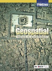
If you’re interested in a detailed look at this growing trend, you should definitely take a look at the most recent On The Frontline publication titled “Geospatial Trends In Government“. In the electronic magazine, Robert Burkhardt, Army Geospatial Information Officer, highlights the four major geospatial trends that are driving the use of Geospatial technologies in government. You can also read about the Army’s Buckey System, which provides high-resolution urban terrain imagery for tactical missions in Iraq and Afghanistan.
No wonder the NGA and Google are moving fast to link up with each other 🙂
![]()

( Thank you. If you enjoyed this article, get free updates by email or RSS – KLJ )
Cloud Computing
- CPUcoin Expands CPU/GPU Power Sharing with Cudo Ventures Enterprise Network Partnership
- CPUcoin Expands CPU/GPU Power Sharing with Cudo Ventures Enterprise Network Partnership
- Route1 Announces Q2 2019 Financial Results
- CPUcoin Expands CPU/GPU Power Sharing with Cudo Ventures Enterprise Network Partnership
- ChannelAdvisor to Present at the D.A. Davidson 18th Annual Technology Conference
Cybersecurity
- Route1 Announces Q2 2019 Financial Results
- FIRST US BANCSHARES, INC. DECLARES CASH DIVIDEND
- Business Continuity Management Planning Solution Market is Expected to Grow ~ US$ 1.6 Bn by the end of 2029 - PMR
- Atos delivers Quantum-Learning-as-a-Service to Xofia to enable artificial intelligence solutions
- New Ares IoT Botnet discovered on Android OS based Set-Top Boxes