
Twitter Feed
SourceConnecte! Marketplace With A Mission
Earlier this year, GC GlobalNet launched a new breed of B2B e-commerce sites. Curated by Kevin L. Jackson, SourceConnecte (with an “eâ€) went live with three strategic goals in mind: Efficiently leverage modern…

Potential vs. Reality: Is Edge Computing Real?
Edge computing provides compute, storage, and networking resources close to devices generating traffic. Its benefits are based on an ability to provide new services capable of meeting stringent operational requirements…

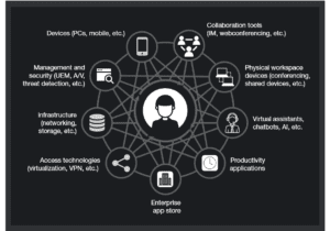
Enabling Digital Transformation
Digital transformation integrates technology into all areas of an organization’s business or mission. Its fundamental purpose is to create and deliver innovative and industry-changing products and services to a global…

The ThinkShield Story Part 1: The Challenge
The cybersecurity challenge seems to be growing daily. Threats are becoming more sophisticated, and attacks are becoming more destructive while the corporate world’s response seems to resemble a deer…

CIO dream team: Who’s in and why?
Today’s CIO navigates the twin challenges of enabling new business models and managing rapid technological change. Cloud computing strategies are now table stakes. CIOs must make complex decisions about using…

Digital Transformation and the Mainframe
Digital transformation infuses digital technology into all areas of an organization’s business or mission. Its fundamental purpose is to create and deliver innovative and industry-changing digital products and services to…

Composable Architecture Q&A. Are you ready?
Q: Is it time for my company to jump on the composable architecture bandwagon? A: Composable architectures are quickly becoming essential to the modern enterprise. Citing a recent Forrester study:…
Increase Productivity by Reducing Technology Distraction: Lessons from Forrester Research
Workplace productivity is hurt every day by the very technology developed and purchased to improve it. Forrester announced this surprising conclusion in their latest “How To Wake Up From The Nightmare…

Unveiling the end-to-end capabilities for the networked society
An Interview with Henrik Basilier By Kevin L. Jackson The telecom industry is rapidly moving towards a future in which networks must have the capabilities of delivering services with the…

AT&T Finance Solutions GM on Shrimping, Software, and CX
Helping clients address the trends and challenges presented by the Financial Services industry is the main focus for René Dufrene in his role as General Manager of Finance Solutions at…
CHANTILLY, Va., July 9, 2013 — NJVC® was selected by Network Centric Operations Industry Consortium (NCOIC) to provide the platform as a service (PaaS) element of a cloud-computing-based humanitarian assistance and disaster response data exchange demonstration.
Google will provide massively scalable, critical geospatial data and mapping services to the demonstration participants. The cloud-based Google Maps Engine product lets users create, share, publish and view (via a browser or Google Earth client) purpose-built maps to address key CHD mission requirements. When needed, Google Earth Server will provide an offline geospatial visualization capability on laptops, tablets and smartphones. These technologies will provide participants the ability to use one of the most familiar technologies in the world, with the same user experience as Google Earth and Google Maps, to easily exchange geospatial information and data within near-real-time operational constraints.
This activity supports cycle two of the geospatial community cloud concept (GCCC) demonstration in support of future disaster relief efforts, and will be conducted on behalf of the National Geospatial-Intelligence Agency (NGA). “Through the cohesive PaaS solution to be delivered by NJVC, first responders will have access to the cloud services that they need—whenever and wherever they need them—and all disaster response activities will be managed from one secure interface,” said Kevin L. Jackson, vice president and general manager, NJVC cloud services. “GeoCloud is the glue to bond disparate apps into one powerful virtual community for first responders. NJVC is thrilled that Google’s technologies will provide the geospatial data backbone for the platform for cycle two of this historic community cloud demonstration.”
“Google is excited about the capabilities this new approach could deliver to first responders worldwide,” said Phil Dixon, IC manager, Google. “We look forward to working with NCOIC and NGA to make this possibility a reality.”
GCCC cycle two will showcase the delivery of basic geospatial PaaS capabilities within the context of a real CHD situation: the 2010 earthquake in Haiti. Cycle two began in early June, and will be a 90-day project.
###
About NJVC
NJVC provides customers with innovative solutions to critical mission, business and technology challenges. As a proven systems integrator for more than a decade, NJVC offers a wide breadth of IT and strategic solutions to clients focusing on IT automation and services integration, real-time predictive analytics, secure cloud services, managed security services and printing solutions. NJVC provides services to both government and commercial customers whose operations depend on high performance, agility and advanced security. We partner with our clients to support their missions with security-cleared, dedicated and talented employees ready to deploy globally. To learn more, visit www.njvc.com.
Google, Google Maps Engine, Google Maps & Google Earth are registered trademarks of Google Inc.
Contact
Michelle Snyder, NJVC, 703.893.7609, michelle.snyder@njvc.com
Audra Capas, 5StarPR, 703.437.9301, audra@5starpr.com

( Thank you. If you enjoyed this article, get free updates by email or RSS – © Copyright Kevin L. Jackson 2012)
–> –> –>
2 Comments
Cloud Computing
- CPUcoin Expands CPU/GPU Power Sharing with Cudo Ventures Enterprise Network Partnership
- CPUcoin Expands CPU/GPU Power Sharing with Cudo Ventures Enterprise Network Partnership
- Route1 Announces Q2 2019 Financial Results
- CPUcoin Expands CPU/GPU Power Sharing with Cudo Ventures Enterprise Network Partnership
- ChannelAdvisor to Present at the D.A. Davidson 18th Annual Technology Conference
Cybersecurity
- Route1 Announces Q2 2019 Financial Results
- FIRST US BANCSHARES, INC. DECLARES CASH DIVIDEND
- Business Continuity Management Planning Solution Market is Expected to Grow ~ US$ 1.6 Bn by the end of 2029 - PMR
- Atos delivers Quantum-Learning-as-a-Service to Xofia to enable artificial intelligence solutions
- New Ares IoT Botnet discovered on Android OS based Set-Top Boxes
Thanks for sharing as it is an excellent post would love to read your future post. computer classes in Baroda
The thought for assortment, information extraction, storage space, dissemination, and exploitation regarding geodetic, geomagnetic, symbolism (both industrial and countrywide sources), gravimetric, aeronautical, topographic, hydrographic, littoral, national, and toponymic data precisely referenced into a correct place on the globe's area.Geospatial Training Services